
The Alpine Club of Williamsport, PA, organized in 1953, maintains the 59.71 mile Loyalsock Trail (LT) and has trail care hikes and other outings. Hike offerings will appear on the Activity Schedule page of this web site. Alpine Club membership is open to anyone over the age of 18.
The Alpine Club invites you to hike the Loyalsock Trail in hopes that you will enjoy, explore, and protect the wild lands and places of natural beauty!
----------------------------------------
Old Logger's Path

The Alpine Club is proud to declare we have added the Old Logger's Path to our mission of Historic Trail maintenance. For more information on this Historic Trail, we invite you to visit their webpage: Old Loggers Path
----------------------------------------
Summer 2026 Trail Runs Alert
This Summer will feature 2 Trail Runs on the Loyalsock Trail. For your safety and the safety of all Trail Runners, all Hikers need to be aware of the dates of those Runs and the general segments of the LT which will be affected on the respective dates. Trail Runners are required to be aware of and to respect the presence of all Hikers, and Hikers are recommended to allow right-of-way to Trail Runners. (There will be no Fall Worlds End Classic nor any Sharp Top Race on the Old Logger’s Path in 2026, as there had been in previous years,) Note the following:
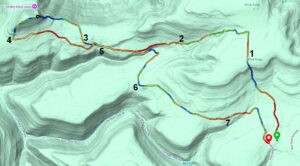
- On Saturday May 30, between 5:00am and Midnight, the LT will welcome the Worlds End Ultra Trail Runs. These consist of 50K and 100K Trail Runs, which begin and end at Worlds End State Park. The Runs traverse through many of that area's hiking trails, logging roads, horse trails, etc. and the Trail Runs intersect with some segments of the Loyalsock Trail between Mile 22.08 (Brunnerdale Road) and Mile 53.32 (the Iron Bridge), additionally including the entire Red-X Link Trail. For more detail, review the following course maps: 50k Course Info 100k Course Info
- On Saturday June 13, between 9:00am and approximately 12:00pm(noon), the LT welcomes the Smith Knob Scramble. This is a short 8-mile Run, which starts at Camp Conley and intersects segments of the LT between Mile 6.24 and Mile 9.10, additionally including the entire Red-X Smith Knob Bypass Trail. For more detail, note the following course map:
Announcement -- New 21st Edition of LT Guide!!
The new 21st Edition of the Guide to the Loyalsock Trail and Side Trails is now available. Go to the Order LT Guides webpage for where to purchase this newest LT Guide with the accompanying Maps.
As more and more major changes and re-routings are made to the LT, as a result of Gas Well activity, PennDot requirements, Park and Forestry recommendations, extreme Weather resolutions, etc., it is recommended that you use this most current 21st Edition of the LT Guide. However, always keep in mind that whichever Edition of the LT Guide and Maps you use, whether something you printed off the Internet or a previous Edition you acquired, you should always follow the Red-Lettered Yellow LT Blazes, to ensure you are on the correct path. We update these Blazes on the Trail as soon as changes are made and before we publish any announcements, addendums or Trail Sign Postings.
You are not lost if you are following this Blaze: ![]()
A few somewhat major route changes are now in this Edition. First is the reroute due to Gas Well activity on the Allegheny Front, between Miles 3.03 and 3.83. The second is the reroute near Worlds End State Park, between Miles 45.57 and 46.58.
We invite you to acquire this new 21st Edition and use it to enjoy arguably the best Hiking Trail in Pennsylvania!
Reporting Storm or Other Trail Damage or Issues
Please report any Storm Damage here
Current Alerts
Standing Alerts
NO FIRES are permitted anywhere on the LT from March 1 to May 25 and at other times when the fire danger is posted as High, Very High or Extremely High. This fire alert applies to the entire Loyalsock Forest and not just the LT.
NO FIRES are permitted in the Haystacks Area at any time.
You should carry a backpack stove.
Blazes used on the Loyalsock Trail

The LT is blazed with yellow disks having red LT letters in the center. Double blazes warn of an upcoming change in direction of the trail.
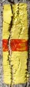
Still visible are old 2" X 6" rectangular yellow paint blazes with a 1" horizontal red stripe. Turns were marked with a yellow directional arrow.
Loyalsock Trail
Alpine Club of Williamsport
The Alpine Club invites you to hike the Loyalsock Trail in hopes that you will enjoy, explore, and protect the wild lands and places of natural beauty!